The best colored map of the United States depends on how you plan to use it: choose a large laminated wall map for display, a double-sided study chart for practice, or a reusable mat for younger learners. The options below include a full-size national map, classroom tools, a blank outline poster, and a regional map for Southeast-focused reference.
| Product | Best For | Key Feature |
|---|---|---|
| 48×78 Huge United States Wall Map | Large wall display | Laminated map measuring 48 by 78 inches |
| JELLY BEAN GENIUS 11×17 Map | Repeated geography practice | Color map on one side, blank outline on the other |
| 36×24 Blank Outline Poster | Labeling activities | Dry-erase poster with answer sheet |
| Southeast US Street Map | Regional reference | Laminated map measuring 42 by 48 inches |
| Teacher Created Resources Learning Mat | Children learning states | Reusable practice mat for ages 6 and up |
48×78 Huge United States Wall Map

This is the best fit for buyers seeking a large national map as a visible wall reference. Its listed size is 48 by 78 inches, and the product name identifies it as a laminated classic United States map. The generous format is suited to a room where a map needs to be seen from across the space.
Choose this if display size is your priority. The listing information provided does not specify map labels, color scheme, mounting hardware, or write-on features, so check those details before buying if they matter to your use.
JELLY BEAN GENIUS Double-Sided Map

This 11-by-17-inch chart has a full-color United States map on the front, with states, capitals, and major regions labeled. The reverse is a blank outline for labeling practice, quizzes, and memory recall. Its laminated surface is designed for use with dry-erase or wet-erase markers.
Best for students, families, and teachers who want both a labeled reference and a reusable study surface. The listing also describes 100-pound cardstock and a protective 3-mil laminate. Its compact chart size is more appropriate for desk or small-group study than a large wall display.
36×24 Blank United States Outline Poster

This 36-by-24-inch laminated poster is built around an unlabeled United States outline. It includes a dry-erase marker and a detailed laminated answer sheet, according to the listing. Those elements make it useful for state-name drills, classroom review, and home geography practice.
Best for buyers who want learners to fill in information rather than rely on a labeled map. The main limitation is that the poster is a blank outline, not a ready-to-read colored reference map; use the answer sheet to check completed work.
Topographics Southeast US Street Map

This 42-by-48-inch laminated street wall map focuses on the Southeast United States. It is the better choice for a buyer who needs a regional map rather than a nationwide overview, such as for studying or referencing that part of the country.
Choose this if the Southeast is your main area of interest. Its regional coverage is also its key limitation: it is not a substitute for a map showing all 50 states. The supplied product details do not specify the states covered or the map’s color and labeling system.
Teacher Created Resources USA Learning Mat
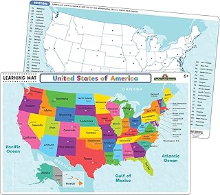
This write-on, wipe-off mat is designed to help students learn the 50 states and capitals. The listing recommends it for ages 6 and up and describes use at home, during meals, or on the go. Its reusable format supports repeated practice without requiring a new worksheet for every session.
Best for children who benefit from hands-on geography activities. The listing says Teacher Created Resources write-on/wipe-off crayons are not included, so buyers should plan to provide a suitable writing tool. It is an activity mat rather than a large wall map.
Buying Guide: How To Choose A United States Map
Do you need a wall display or a study tool?
For a prominent wall reference, compare the 48-by-78-inch national map with the 36-by-24-inch blank poster. A labeled map is easier to consult immediately, while an outline map is better for recall exercises. For desk-based or portable practice, the 11-by-17-inch chart and learning mat are more compact formats.
Should the map be labeled or blank?
Choose a labeled map when the main goal is finding states, capitals, or regions. Select a blank outline when students need to write labels from memory. The double-sided chart combines both approaches, with a labeled front and an outline back.
Is a regional map enough?
A Southeast map can offer a focused view of that region, but it does not replace a nationwide map. Confirm the map’s coverage and included labels in the listing if you need a specific state, city, or geographic detail.
Will you write on the map?
Look for explicit dry-erase or wet-erase information if repeated writing is important. The JELLY BEAN GENIUS chart is described as compatible with both marker types, while the outline poster includes a dry-erase marker. The learning mat is reusable, but its listed crayons are not included.
Frequently Asked Questions
What is the best colored map of the United States for a classroom?
The double-sided 11-by-17-inch chart is a strong classroom option because it has a labeled color map on one side and a blank outline for practice on the other.
Which option is best for learning state names?
The blank outline poster and reusable learning mat are suited to practice. The poster is laminated and comes with an answer sheet; the mat is designed for learning the states and capitals.
Are all five products maps of the entire country?
No. The Topographics product is specifically a Southeast US street map. The other product names and descriptions identify national United States maps or learning materials.
Which map is largest?
The 48-by-78-inch United States wall map is the largest by the dimensions provided.
What should I check before ordering?
Confirm the map’s dimensions, geographic coverage, labels, writing surface, and whether markers or other supplies are included. These details vary by product.